NSW Family History
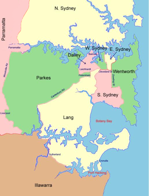
Index Map of Sydney Electoral Divisions 1900
Dalley
This electoral division includes the Sydney suburbs of Glebe, Forest Lodge, Annandale, Leichhardt, Lilyfield, Rozelle and Balmain.East Sydney
This electoral division includes the area from George St east to Woolloomooloo, Potts Point, Kings Cross and Darlinghurst, and south to Cleveland St.Lang
Includes the suburbs of Arncliffe, Bexley, Camperdown, Dulwich Hill, Enmore, Hurstville, Newtown, Marrickville, Rockdale, Sydenham and Tempe, the area to the south-east of Canterbury Road and east of Salt Pan Creek to Botany Bay, and Sutherland Shire north of Port Hacking and Saville's Creek, and east of the Woronora River.North Sydney
Includes Gosford and Wyong and the area north from Port Jackson and the Parramatta River to Morrisset and Lake Macquarie.Parkes
Includes Petersham, Lewisham, Summer Hill, Drummoyne, Five Dock, Ashfield, Croydon, Concord, Enfield, Mortlake, Burwood, Strathfield, Homebush, Flemington, Rookwood, Auburn, Granville, Clyde, Bankstown and Canterbury.South Sydney
Includes the suburbs of Alexandria, Darlington, Erskineville, Macdonaldtown, Newtown, Redfern, Waterloo and Zetland, and areas south to Banksmeadow and Botany.Wentworth
Includes Bondi, Bronte, Coogee, Edgecliffe, Kensington, Moore Park, Randwick, Vaucluse and Waverley.West Sydney
Includes the area to the west of George St and the suburbs of Ultimo, Pyrmont, Chippendale and Glebe (east of Glebe Point Rd).Copyright © Internet History Resources 2006